Automated Extraction of Building Footprints from Radar Images
Sandhi Wangiyana
supervisor: Piotr Samczyński
Remote sensing images are valuable for geospatial analysis of a large area, such as finding the polygons of buildings from an aerial view. Optical data is usually preferred, but it requires good sunlight and little cloud coverage. Synthetic Aperture Radar (SAR) has the benefits of providing remote sensing data in all weather conditions. This is valuable in situation where prompt analysis is needed such as in aiding disaster response. But the unique properties of the radar image pose challenges in image analysis, requiring the domain knowledge of SAR experts and advanced processing tools to interpret the image.
With many satellite constellations we have currently and more in the future, the amount of SAR data is growing fast. Convolution Neural Network (CNN) can be used to augment or automate the process of SAR analysis, utilizing the massive collection that we’re storing each day.
We studied how SAR resolution impacts a model’s performance in segmenting building footprints. To achieve this, we used the publicly available SpaceNet 6 dataset and applied low pass filters with varying strength to create datasets with different SAR image clarity. We train the dataset variations on 2 encoder-decoder architectures: Feature Pyramid Network (FPN) and U-Net. We obtained interesting findings where FPN’s performance drop slightly as stronger filter is applied, while U-Net had slight performance gain when weak filtering is applied.
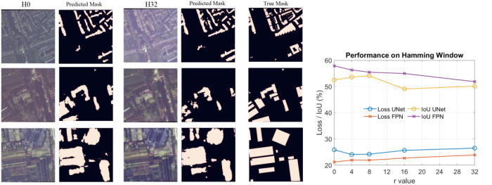
Fig. 1 Left: prediction results from the model on original dataset (H0) compared to dataset with hamming window filtered applied (H32). Right: Model’s performance based on Intersection over Union (IoU) and loss metric.